In July I climbed an Oregon high peak in the Elkhorn Range of Northeast Oregon and a prominent peak in the Cabinet Range of Northern Idaho.
Cougar Pond SW Peak
On Tuesday, July 7, I drove to Baker City, Oregon, and checked road status at the local Forest Ranger Station. Then I drove west up along Pine Creek on the east side of the Elkhorn Range. The Pine Creek Road was quite rough. I recommend 4WD, good clearance, and tough tires to drive up to where parking is allowed beyond private property. I spent a pleasant evening and night camped beside the road.
The next morning, Wednesday July 8, I hiked up further along the primitive road. This road eventually became more of an ATV track as it approached Pine Creek Reservoir. I hiked past the reservoir, then followed the track as it switchbacked north up a slope towards a saddle.
The last 400 feet to the saddle was on an unimproved trail through a flowering meadow. Some mountain goats were visible on the slopes above and to my left. Rock Creek Butte rose far above me to the west.
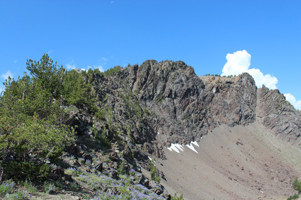
From the saddle, Cougar Basin extended below me to the north. My destination, the unofficially named “Cougar Pond Southwest Peak”, rose above me to the west. Cougar Pond SW Peak is Oregon’s 39th highest peak (with at least 500 feet of prominence). From the saddle I climbed open ground and through thin forest to find the summit on the NW end of the summit ridge.
I enjoyed identifying most of the 12 other Oregon 100 highest peaks in the Elkhorn Range from the summit. I noticed a thunderstorm brewing above Mount Ireland to the NW.
My plan was to return to the saddle and hike up Cougar Pond SE Peak rising above the saddle to the east. But when I returned to the saddle a booming thunderstorm was quickly approaching. I decided reluctantly it was most prudent to get off the ridge line and return to my car.
Scotchman Peak
I spent Wednesday night in La Grande, Oregon. Thursday I drove to the Scotchman Peak Trailhead near Clark Fork, Idaho, east of Sand Point. Here I camped for the night. Scotchman Peak is number 76 of the 100 most prominent peaks of the US 48 contiguous states with 4648 feet of prominence. It also has a very popular trail to the summit and reportedly has great views of Lake Pend Oreille below.
Friday was going to be another hot day, so I got an early start on the Scotchman Peak Trail. The trail began steeply, but after about 700 feet of gain the grade lessened. From there the hike to the summit was quite pleasant.
I frequently banged my hiking poles together as I hiked on the trail. This was to let any bears near the trail know I was coming so we did not have any unexpected encounters. This was apparently effective, as I saw or heard no bear on my hike up.
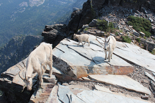
As soon as I reached the Scotchman Peak summit I was approached and greeted by three mountain goats. They were eager to lick or chew my sweat-coated pack, pole leashes, shirt, and arms. These were the most insistent and bold goats I have seen in the mountains. I eventually emptied several salt capsules on rock slabs to distract the goats.
I took photos of them and the scenery, then explored another potential summit to the east. When it was time to descend I said my goodbyes to the goats and wished them all the best. Another goat had just arrived and I encountered two more as I descended high on the trail.
I met several hikers climbing as I descended. From them I heard that a bear was just off the trail lower on the trail below me. I continued my noise-making as I descended. At one point I heard what was likely a bear crashing through brush to my right.
Snowshoe Peak
After returning to the trailhead I drove on through Libby, Montana, and up to the Leigh Lake Trailhead. This was my camp for Friday night. Here I expected to meet two friends, Caleb and Troy, for the next day’s attempt of Snowshoe Peak. Snowshoe Peak has 5442 feet of prominence. It is one of the 57 “Ultra Prominence” peaks in the 48 US Contiguous States. Caleb and Troy eventually arrived during a rainstorm and hastily set up their tents for the night.
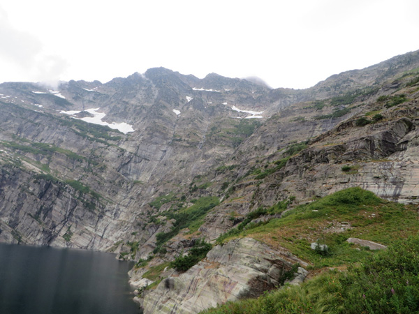
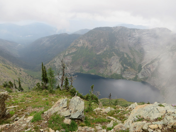
Saturday morning, July 11, Caleb, Troy, and I left the trailhead and hiked to Leigh Lake below the NE ridge of Snowshoe Peak. As we approached the lake we could see what appeared to be the summit of Snowshoe Peak high above us. But soon after arriving at the lake the summit began to be hidden in clouds.
From Leigh Lake we climbed and traversed rocky and grassy gullies and slopes 2200 feet to reach the NE Ridge of Snowshoe Peak. By this time the NE Ridge just above us and the upper mountain were completely clouded up. Waves of rain showers were starting to wash over the ridge. Surges of moisture were also pushing up the valleys around us and there was no near-term prospect of improvement. We decided we could not risk climbing the last 1400 feet of slick rock slabs in fog and rain. It was time to descend.
The steep, wet, grassy, muddy, and rocky descent in rain showers back down to the lake and trail was physically and mentally exhausting for me. Perhaps I was also tired after my previous hikes. I wrung out my soaked socks and emptied my boots of water a second time. Then I followed Caleb and Troy through brush and steep trail back to the trailhead.
Our plan was to then move on towards Northwest Peak in the NW corner of Montana for Saturday’s camp and Sunday’s hike. But showers and thunderstorms had settled in for the weekend. Unable to find a dry site for the evening and night we independently decided to return to our homes.
It had been a sobering and disappointing day for me, but the Cabinet Mountains are a magnificent place to visit. I am sure a climb of Snowshoe Peak would be a completely different experience in dry conditions with good visibility. I hope to return next summer.

Leave a Reply