GlassMountains Trip Reports

Exploring the backcountry and wilderness of the Western USA.

Trip Reports

  • SITE HOME
  • ALL
  • BICYCLING
  • CLIMBING
  • HIKING
  • SKIING
  • FAMILY

Golden Gate Mountain, Arizona, January 2016

January 14, 2016 by Paul McClellan Leave a Comment

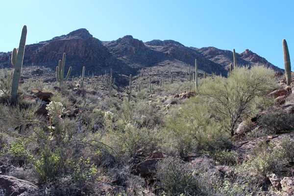
On Tuesday, January 12, I climbed Golden Gate Mountain, just west of Gates Pass in the Tucson Mountains. I climbed the Northeast slope from the David Yetman West Trailhead. The weather was ideal and the views were excellent. The upper slope was a bit steep but the footing was firm with some fun rock scrambling. Most of the brush was avoidable. I had the summit to myself and met only one party on my descent.

Golden Gate Mountain from above David Yetman Trail

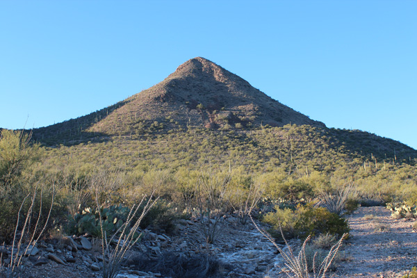
The Northeast slope of Golden Gate Mountain is a fan-like slope descending from rock bands below the north summit. It lies between two drainage channels leading towards Golden Gate Pass above the David Yetman Trail. It is just right of center in the above photo.

[Read more…] about Golden Gate Mountain, Arizona, January 2016

Filed Under: Climbing Tagged With: Arizona, Golden Gate Mountain, Tucson Mountain Park

Roskruge Mountains, Arizona, January 2016

January 6, 2016 by Paul McClellan 1 Comment

Saturday, January 2, I joined the Southern Arizona Hiking Club on two climbs west of Tucson in the Roskruge Mountains. I drove and gave my Jeep a workout on the rutted and rocky roads and tight squeezes through abrasive brush. My Jeep’s “Arizona Striping” is getting quite pronounced now. The peaks have low elevation but have interesting climbs with fine views of the surrounding mountains.

Martina Mountain from the Jeep trail

Our first climb was of Martina Mountain which provided a fine view of the nearby Coyote Mountains. We hiked cross country up the ramp in the sunlight on the left side of the above photo. Then we then climbed up a rocky band to the summit. We climbed 1100 feet in about 0.8 mile and enjoyed the scrambling over rocks near the top.

[Read more…] about Roskruge Mountains, Arizona, January 2016

Filed Under: Climbing Tagged With: Arizona, Martina Mountain, Roskruge Mountains, Sharp Peak, Southern Arizona Hiking Club

Atascosa Peak, Arizona, December 2015

January 3, 2016 by Paul McClellan 1 Comment

On New Years Eve I hiked Atascosa Peak, the highpoint of the Atascosa Mountains of Southern Arizona. Atascosa Peak is one of the “Coronado 12” peaks, the highpoints of the 12 units of the Coronado National Forest. With 1976 feet of topographical prominence it is the 78th most prominent peak in Arizona.

There was a nice trail leading to the Atascosa Lookout site. From there I descended to the saddle north of the lookout site and up to the summit of Atascosa Peak. This required cross country travel with some scrambling over class 2-3 rock and through some brush. The weather was ideal and I had the traverse out to the summit and back all to myself.

Atascosa Peak from above Peña Blanca Lake

The above photo is of Atascosa Peak looking west from above Peña Blanca Lake near the end of Arizona highway 289. The Lookout site is located on the high point on the left. The summit of Atascosa Peak is the high point on the right, about 1 mile north of the lookout site.

[Read more…] about Atascosa Peak, Arizona, December 2015

Filed Under: Climbing Tagged With: Arizona, Atascosa Peak

Table Top Mountain, Arizona, December 2015

December 23, 2015 by Paul McClellan 1 Comment

Sunday, December 13, I hiked Table Top Mountain, the highest point of the Table Top Mountains west of Casa Grande, Arizona. Table Top Mountain has 2339 feet of prominence, making it the 48th most prominent peak in Arizona.

Table Top Trail is a maintained trail leading to the SW (false) summit of Table Top Mountain. From there, an unmaintained trail leads to the true summit to the northeast. I enjoyed hiking the trails and viewing the surrounding mountains and valleys in clear skies and pleasant temperatures.

Approaching the Table Top Trailhead

For many visitors, the challenge of visiting Table Top Mountain is the drive. The drive starts with 11.2 miles of dirt/gravel Vekol Valley Road. Then it concludes with 4.5 miles of dirt/rock access road to the Table Top Trailhead.

There were several ruts where washes crossed the roads which required high clearance. The last few miles to the trailhead was on a rocky road with narrow passages through spiny vegetation and over an occasional cholla stem. I had no issues driving these roads with my Jeep with its excellence clearance and 10-ply tires. However, I did add “Arizona pin stripes” to the sides of my Jeep.

[Read more…] about Table Top Mountain, Arizona, December 2015

Filed Under: Hiking Tagged With: Arizona, Table Top Mountain, Table Top Mountains, Vekol Valley

« Previous Page
Next Page »

RECENT POSTS

  • Cookes Peak, New Mexico, February 2026
  • Tandem Skydiving, Oregon, August 2025
  • Castle Rock, Oregon, August 2025
  • Fish Creek Mountain, Oregon, July 2025

MONTHLY ARCHIVES

Blogroll

  • Arizona Peaks (Peavy)
  • Cycle Uphill (Sharp)
  • Desert Mountaineer (Kasian)
  • Earthline: The American West (Van Winegarden)
  • jessb.org (Beauchemin)
  • New Bohemians (Rogers)
  • Stav is Lost
  • The Mountains of Arizona (Surgent)
  • The Zenith (Baker)

Site content Copyright © 2026 Paul J. McClellan. All rights reserved.
Copyright Details
Log in