On February 5 I climbed Newman Peak, the highest point in the Picacho Mountains north of Tucson, Arizona. With 2529 feet of topographic prominence it is also the 38th most prominent peak in Arizona.
Newman Peak has a reputation for difficult access and brushy and rocky slopes. So I did my homework beforehand. I researched the driving route from online reports, USGS topo maps, and satellite images.
The previous afternoon I drove in to below Newman Peak from the south on primitive roads. I carried my driving notes with me, updating them as I worked my way in. My drive crossed the Central Arizona Project Canal without issue in two places. As I passed through the first of three gates I entered Arizona State Trust Land. I carried my annual Arizona State Land recreational permit.
Here are my driving notes:
- Take Exit 219 off I-10.
- 0.0 mi – Zero your odometer at the Frontage Road on the east side. Turn right and head south.
- 5.0 mi – Turn Left onto paved Park Link Drive and cross two railroad tracks.
- 5.8 mi – Turn Left onto paved Pecan Road. Head north on good pavement.
- 10.8 mi – Continue Straight onto a primitive dirt road as the pavement continues right on Harmon Road.
- 10.9 mi – Turn Left onto another primitive dirt road.
- 11.6 mi – Pass through a gate onto State Trust Land (permit required). Immediately Turn Right and drop into a broad wash.
- 11.9 mi – Climb out of the wash and immediately Turn Right.
- 12.2 mi – pass through a second gate as you cross over the buried CAP Canal.
- 12.3 mi – Turn Right, then cross a short wash.
- 12.5 mi – Cross a cattle guard.
- 12.6 mi – Bear Right towards a bridge over the CAP Canal.
- 12.7 mi – Cross the bridge and Bear Slightly (not hard) Right.
- 12.8 mi – Turn Left at a fork.
- 13.2 mi – Pass camp sites.
- 13.3 mi – Continue Straight at a junction (not right).
- 13.4 mi – Turn Right at a T junction and follow along a fence.
- 14.4 mi – Turn Right at a T junction and pass through a wire gate.
- 15.3 mi – I camped at 2190 ft elevation.
- 15.5 mi – Pass the fenced game water facility (do not camp within 1/4 mile).
The road soon drops down into a wash and gets rougher. - 15.9 mi – Turn Right at a junction.
- 16.4 mi – Road ends.
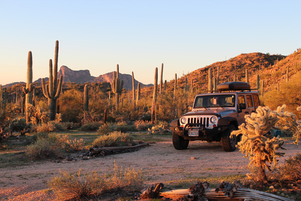
My plan was to camp for the night so as to be ready for an early start the next morning. Driving in, I found a nice opening amongst saguaro, cholla, and prickly pear cactus just off the road. It was about a quarter mile before a fenced game water facility.
I set my tent up beside my Jeep. Then I enjoyed dinner in my camp chair with a celebratory Black Butte Porter and Rampant IPA. The evening and night at camp was quiet with only the occasional sound of a nearby saguaro skeleton rattling in the breeze.
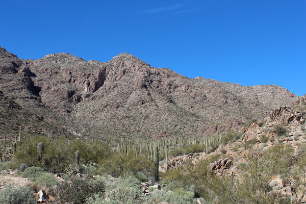
The next morning I followed the road to its end. Beyond the road I traveled cross country around brush and cactus and over a few washes. Then I traversed up to my right across slopes to reach a deep gully. From there the gully led steeply upwards between rocky ridges. My eventual route, the ESE Ridge, descends left to right below the right skyline in the above photo.
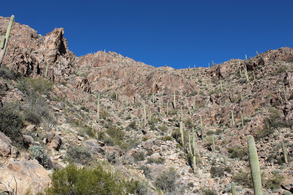
I pondered the route to take upwards. The ridge to the left seemed too steep for me. I considered descending into the wash to my right, then climbing up over rock bands directly towards the ridge line above. But I thought one of the rock bands might be problematic. Instead, I decided to cross the wash and traverse right to reach the far ridge before ascending.
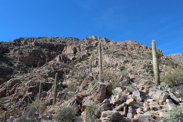
I called this ridge the ESE Ridge, between the Southeast Ridge to the left and the East Ridge to the right described in earlier reports. This rocky ridge had mostly firm footing and was fun to climb with occasional class 3 rock. Near the top of the ridge I traversed over talus and through brush below a cliff to reach an easier ridge leading higher.
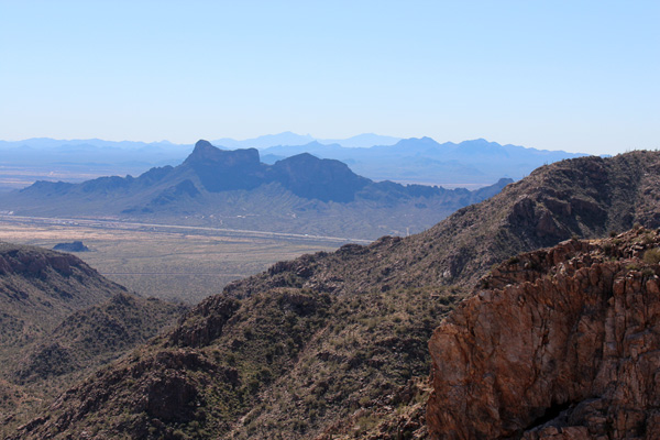
As I climbed the ESE Ridge I began to get good views of other peaks. For example, in the photo above Picacho Peak is the shady, cliffy peak just beyond I-10. In addition, beyond Picacho Peak to the right are the Silver Bell Mountains. Further yet are Coyote Mountain and Kitt Peak. Finally, the tower of Baboquivari Peak is just visible in the far distance between Coyote Mountain and Kitt Peak.
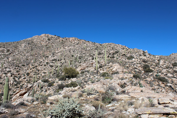
I enjoyed walking up the upper ridge with its firm footing and open slopes. Yet, for much of this walk, the summit with its communication towers remained out of view beyond the ridge ahead. Finally, I saw the towers ahead and arrived at the summit.
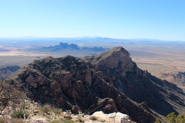
It was a nice day for climbing and the route was challenging enough and fun. From the summit I enjoyed identifying many surrounding ranges and peaks. I plan to revisit Coyote Mountain soon to hopefully summit. Next fall I hope to visit Baboquivari Peak before snow and ice complicate climbing its tower.
I descended the same route to my car. As always I was thankful when I arrived to see the tires were still inflated and the engine started without trouble. After a pleasant rest I retraced the drive out with the help of my Jeep navigation system.

Leave a Reply